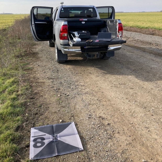
South G3 drón bázis
South G3 drón bázis
A South G3 Drón bázis fő előnyei:
- Nincs szükség mobil internetre
- Nincs szükség hálózati korrekcióra
- Egyenletes és folyamatos centiméteres pontosság
- Telepítés 5 másodperc alatt
Napjainkban az RTK helymeghatározás egyre bizonytalanabb az ionoszféra aktivitása miatt. Vannak olyan mezőgazdasági területek ahol nics mobil internet szolgáltatás.
A professzionális dron monitoring megköveteli a homogén , centiméter pontos felvételek sorozatát. A South drón bázis egyszerűen és gyorsan megoldja ezeket a problémákat.
A South drón bázis az DJI és Autel gyártók RTK drónjaival működik együtt.
Kérje bemutatónkat: info@gpscom.hu
| GNSS Features | Channels | 1598 |
| GPS | L1, L1C, L2C, L2P, L5 | |
| GLONASS | L1C/A,L1P,L2C/A,L2P,L3* | |
| BDS | BDS-2: B1I, B2I, B3I BDS-3: B1I, B3I, B1C, B2a, B2b* | |
| GALILEOS | E1, E5A, E5B, E6C, AltBOC* | |
| SBAS(WAAS/MSAS/EGNOS/GAGAN) | L1* | |
| IRNSS | L5* | |
| QZSS | L1, L2C, L5* | |
| MSS L-Band | BDS-PPP | |
| Positioning output rate | 1Hz~20Hz | |
| Initialization time | < 10s | |
| Initialization reliability | > 99.99% | |
| Positioning Precision | Code differential GNSS positioning | Horizontal: 0.25 m + 1 ppm RMS Vertical: 0.50 m + 1 ppm RMS |
| Static(long observations) | Horizontal: 2.5 mm + 1 ppm RMS Vertical: 3 mm + 0.4 ppm RMS | |
| Static | Horizontal: 2.5 mm + 0.5 ppm RMS Vertical: 3.5 mm + 0.5 ppm RMS | |
| Rapid static | Horizontal: 2.5 mm + 0.5 ppm RMS Vertical: 5 mm + 0.5 ppm RMS | |
| PPK | Horizontal: 3 mm + 1 ppm RMS Vertical: 5 mm + 1 ppm RMS | |
| RTK(UHF) | Horizontal: 8 mm + 1 ppm RMS Vertical: 15 mm + 1 ppm RMS | |
| RTK(NTRIP) | Horizontal: 8 mm + 0.5 ppm RMS Vertical: 15 mm + 0.5 ppm RMS | |
| RTK initialization time | 2 ~ 8s | |
| SBAS positioning | Typically < 5m 3DRMS | |
| BANDA-L | Horizontal: 5-10cm (5-30min) Vertical: 10-30cm (5-30min) | |
| IMU | Less than 10mm + 0.7 mm/° tilt to 30° | |
| IMU tilt angle | 0° ~ 60° | |
| Hardware Performance | Dimension | 130mm(W) ×130mm(L) × 80mm(H) |
| Weight | 790g (battery included) | |
| Material | Magnesium aluminum alloy shell | |
| Operating temperature | -45℃ ~ +65℃ | |
| Storage temperature | -45℃ ~ +85℃ | |
| Humidity | 100% Non-condensing | |
| Waterproof/Dustproof | IP68 standard, protected from long time immersion to depth of 1m IP68 standard, fully protected against blowing dust | |
| Shock/Vibration | Withstand 2 meters pole drop onto the cement ground naturally MIL-STD 810G | |
| Power supply | 6-28V DC, overvoltage protection | |
| Battery | Inbuilt 7.2V 6800mAh rechargeable, Li-ion battery | |
| Battery life | 15h (Rover Bluetooth mode) | |
| Communications | I/O Port | 5-PIN LEMO external power port + RS232 Type-C (charge, OTG to USB disk, data transfer with PC or phone, Ethernet) 1 UHF antenna TNC interface |
| Internal UHF | 2W radio, receive and transmit, radio router and radio repeater | |
| Frequency range | 410 - 470MHz | |
| Communication protocol | Farlink, Trimtalk450s, SOUTH, HUACE, Hi-target, Satel | |
| Communication range | Typically 8km with Farlink protocol | |
| NFC Communication | Realizing close range (shorter than 10cm) automatic pair between receiver and controller (controller requires NFC wireless communication module else) | |
| Bluetooth | Bluetooth 3.0/4.1 standard, Bluetooth 2.1 + EDR | |
| WIFI | Modem | 802.11 b/g standard |
| WIFI hotspot | AP mode, Receiver broadcasts its hotspot form web UI accessing with any mobile terminals | |
| WIFI datalink | Client mode, Receiver can transmit and receive correction data stream via WiFi datalink | |
| Data Storage/Transmission | Storage | 4GB SSD Automatic cycle storage (The earliest data files will be removed automatically while the memory is not enough) Support external USB storage |
| Data transmission | Plug and play mode of USB data transmission Supports FTP/HTTP data download | |
| Data format | Static data format: STH, Rinex2.01, Rinex3.02 and etc. Differential format: RTCM 2.3, RTCM 3.0, RTCM 3.1, RTCM 3.2 GPS output data format: NMEA 0183, PJK plane coordinate, SOUTH Binary code Network model support: VRS, FKP, MAC, fully support NTRIP protocol | |
| Sensors | Electronic bubble | Controller software can display electronic bubble, checking leveling status of the carbon pole in real-time |
| IMU | Built-in IMU module, calibration-free and immue to magnetic interference | |
| Thermometer | Built-in thermometer sensor, adopting intelligent temperature control technology, monitoring and adjusting the receiver temperature | |
| User Interaction | Operating system | Linux |
| Buttons | One button | |
| Indicators | 5 LED indicators(Satellite, Charging, Power, Datalink, Bluetooth) | |
| Web interaction | With the access of the internal web interface management via WiFi or USB connection, users are able to monitor the receiver status and change the configurations freely | |
| Voice guidance | It provides status and operation voice guidance, and supports Chinese/English/Korean/Spanish/Portuguese/Russian/Turkish | |
| Secondary development | Provides secondary development kit, and opens the OpenSIC observation data format and interaction interface definition | |
| Cloud service | The powerful cloud platform provides online services like remote manage, firmware update, online register and etc. |
Keresse szakértőnket!
GPS szakmérnökként célom a partnereink megoldáscentrikus, személyre szabott kiszolgálása helymeghatározó és adatgyűjtő rendszerekkel. Precíziós Mezőgazdálkodási szakértőként olyan mérési és döntéselőkészítési rendszereket ajánlok, amelyek gazdaságossá teszik mezőgazdasági partnereink mindennapi munkáját és fenntarthatóvá és felelőssé teszik gazdaságát.


